COUNTDOWN TO TOTALITY* 22.07.28
Day(s)
:
Hour(s)
:
Minute(s)
:
Second(s)
Where To View The Australian Total Solar Eclipse 2028
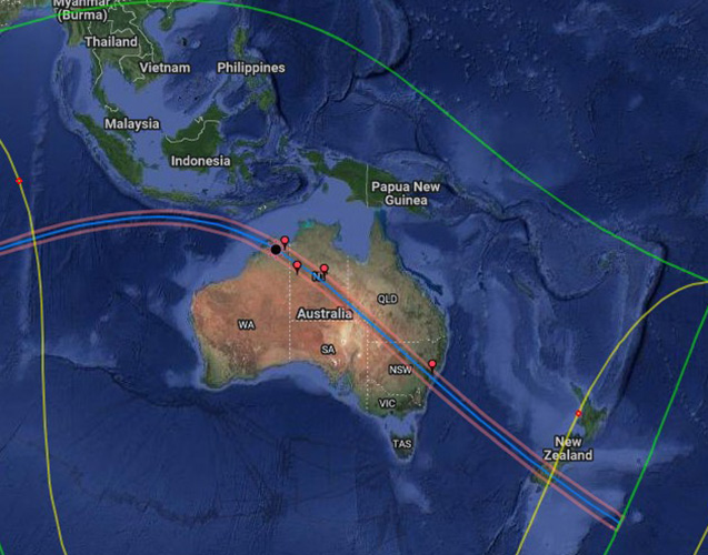
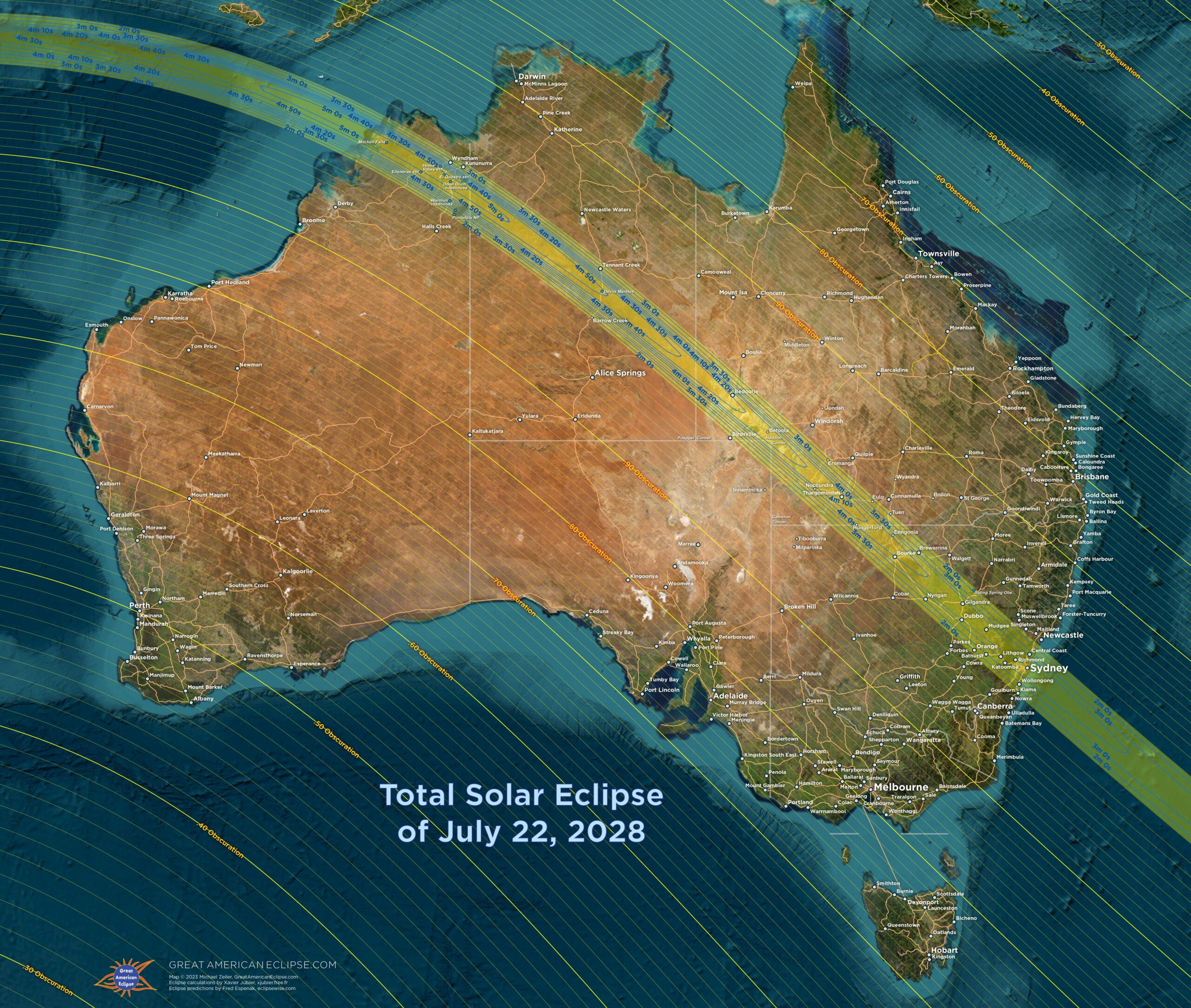
For the 22 July 2028 solar eclipse the Moon’s shadow will start in the Indian Ocean to the west of Australia.
Michael Zeiler / GreatAmericanEclipse.com
It will cross the Australian territories of Cocos (Keeling) Islands and Christmas Island before making landfall in the Kimberley area of Western Australia with Wyndham and Kununurra in the path.
Further on in Western Australia it moves over the Purnululu (Bungle Bungle) National Park. Moving into the Northern Territory, it passes over Tennant Creek and the Devils Marbles. Into south-west Queensland, it passes over Bedourie and Thargomindah. Into New South Wales, Bourke and Dubbo are in the path.
Finally it passes over Sydney with the entire Greater Sydney area in the path (from Lake Macquarie to Kiama). The shadow then passes over the Tasman Sea crossing the South Island of New Zealand with Queenstown and Dunedin in the path before finishing in the Southern Pacific Ocean.
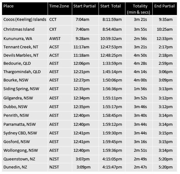
The table below gives the time of the total eclipse at various locations along the path
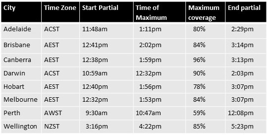
At the same time, the whole of Australia will experience a partial solar eclipse – a solar eclipse seen from within the Moon’s penumbra, where the Moon appears to block part (but not all) of the Sun’s surface (the photosphere).
The table below gives the times of the partial eclipse that will occur at capital cities
Check the interactive map below to see the path of the total eclipse across Australia and the time of the eclipse at any observing location on the path.
Zoom in and click on the location to show a pop up box with the time and duration of the total eclipse as well as the times of the start and end of the partial phases.
Note that the times are in Universal Time, but that can be changed to local time by clicking on the clock icon on the left hand side of the screen.
The altitude of the Sun as well as its direction are also shown.
See HERE for a description of the total solar eclipse experience.
The interactive map above will show the maximum coverage of the Sun for a partial eclipse at any location outside the path of totality.
Zoom in and click on any location outside the path of totality to show a pop up box with the timing of the start and end of the partial eclipse and maximum coverage of the Sun.
(The magnitude figure is the maximum coverage of the diameter of the Sun at the location.)
See HERE for what to experience during a partial eclipse.
Do not look at a partial eclipse or the partial phases of a total eclipse – use eclipse glasses or a projection method as described HERE.
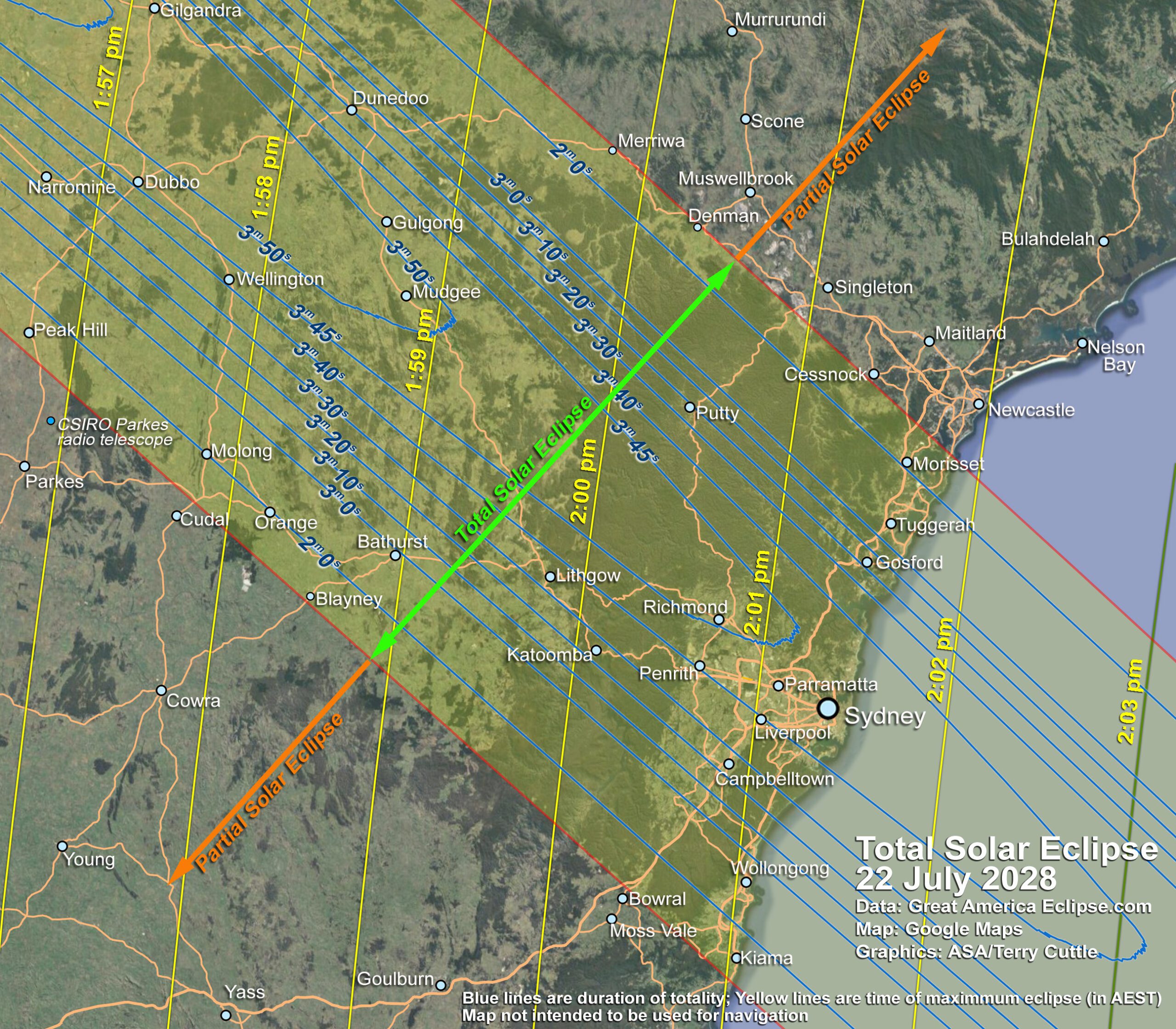
The Sydney area of New South Wales will be of great interest with the large number of people living in that area. The Map below shows the area that will be covered by the total eclipse highlighted. The blue lines give an indication of the duration of totality across the path in minutes and seconds and the yellow lines are an indication of the time of maximum eclipse (in AEST).
Map: Google Map; Eclipse data: greatamericaneclipse.com
Weather
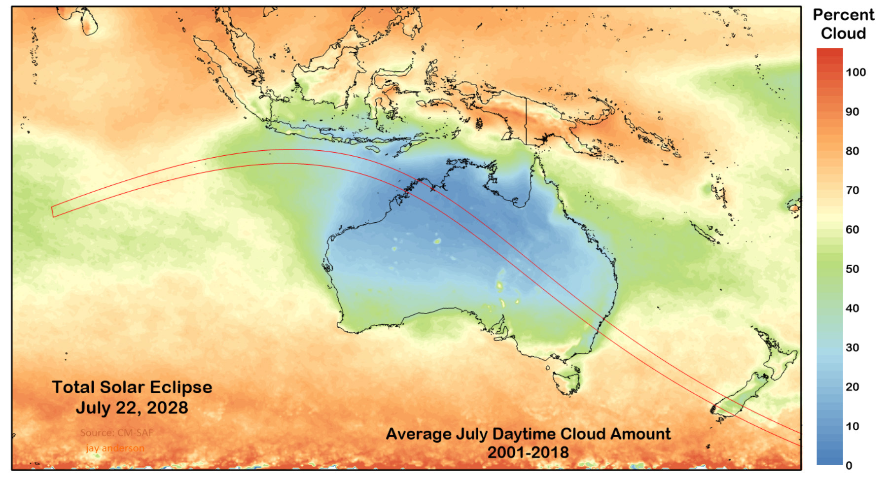
The diagram shows the mean July cloud cover as derived from 18 years of satellite data.
The diagram is from Jay Anderson’s eclipse weather site where climate details for the eclipse path are available.
The diagram indicates generally better weather prospects in the north-western part of the eclipse track over Australia.
Weather prospects 2028 Eclipse
Weather: CM-SAF satellite; Eclipse track Xavier Jubier; Graphics: Map by Jay Anderson
The Sky during totality
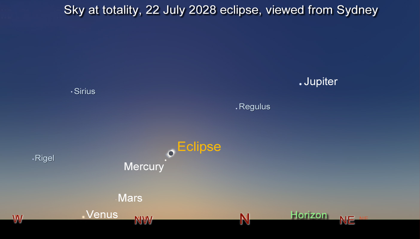
The diagram below shows where the eclipse will occur in the sky as viewed from Sydney and includes the approximate location of planets and stars that may be visible during the eclipse.
The view of the eclipse, planets and stars will be similar at locations other than from Sydney. Further to the north-west in Australia, the eclipse and planets will be higher in the sky and further towards the east.

